Hungary Opens Airspace Again After Re-Introducing Flight Restrictions
- 21 Apr 2010 6:00 AM
"Hungary, being far from the eruption and the air space where ashes are present in high concentration, similar to neighbouring countries ... considers its air space below 6,000 metres (19,680 ft) as a low concentration area," said Gyula Hangyal, Deputy Director of Hungarocontrol.
Hungarocontrol will revise its assessment of the situation once in every six hours.
Hungarian air traffic authorities implemented no-fly regulations at 7 PM on Friday over plume from a volcanic eruption in Iceland that paralysed Europe’s air traffic. The airspace closure was extended several times and was finally lifted at noon on Monday.
However, at 2 AM on Tuesday Hungarocontrol has re-introduced the ban to use the airspace west of the Balassagyarmat-Szentgotthárd line below 6,000 metres and said the area east of that line is likely to be a no-fly zone as of 8 AM too.
While the volcanic ash cloud withdrew from over Hungary towards the north, westerly winds blew another cloud of ash over the country that was forecasted to reach the Budapest-Nagykanizsa line by 8 AM.
HungaroControl and OMSZ have called a joint press conference for 10 AM today.
A single plane was able to take off from Ferihegy on Tuesday, bound for Naples, Budapest Airport spokesman Károly Szilágyi told news portal index.hu. Although full airspace closure enters into effect only from 08:30 west of the Baja-Miskolc line, airlines have cancelled their Tuesday flights due to the uncertainties.
European aviation control agency Eurocontrol, which co-ordinates air traffic control in 38 nations, said that around 8,700 flights took place on Monday in European airspace.
At the time Eurocontrol gave its latest update on Monday evening, air traffic control services were not being provided to civil aircraft in the major part of European airspace. This included Belgium, Denmark, Estonia, Finland, Germany, Ireland, the Netherlands, northern Italy, Romania, Slovenia, Switzerland, parts of Ukraine and the UK. In some of these areas the upper airspace has been made available, depending on the observed and forecasted area of possible ash contamination.
"However, it is difficult to access this airspace as in most cases the surrounding area is not available for flights."
Flights were taking place in southern and central Europe, including the Czech Republic, the Balkan area, Bulgaria, Hungary, southern Italy and France, Greece, Poland, Portugal, Slovenia, Spain, and Turkey, as well as parts of northern Europe (Norway and parts of Sweden).
Around 600 trans-Atlantic flights take place each day, 300 in each direction. Of the 300 flights that would usually arrive in Europe, 219 flights arrived in Europe on Monday, and 233 left Europe.
"Eurocontrol, the air navigation service providers and the airlines are working closely together to ensure that whenever airspace becomes available, even if it is only for a short time, flights are able to take place in the most efficient and safe manner."
You find the latest updated map of observed and forecasted area of possible ash contamination below. 
NATS, the UK's leading air navigation services provider, said in its latest report today that since its last statement at 21:00 (local time) yesterday, the volcano eruption in Iceland has strengthened and a new ash cloud is spreading south and east towards the UK.
Latest information from the Met Office shows that the situation is variable. The Met Office said late on Monday that eruptions from the Eyjafjallajökull volcano were weaker than they were at the weekend but eruptions still take ash over 10,000ft at times. Weather patterns continue to blow areas of ash towards the UK.
The Met Office is the North-west European Volcanic Ash Advisory Centre with responsibility for issuing the Volcanic Ash Advisories for volcanoes erupting in this area.
The ash cloud basically consists of fine particles of pulverized rock. Volcanic ash is a rare but potentially catastrophic hazard to aviation. Encounters with volcanic ash while in flight can result in engine failure from particulate ingestion and viewing obstruction of the cockpit widescreen from etching by the acidic aerosols. Volcanic Ash Advisory Centers were established to monitor the air space in areas prone to eruptions and to issue volcanic ash warnings.
Eyjafjallajökull is one of Iceland's smaller glaciers, located north of Skógar. Skógar is a small Icelandic village with a population of roughly 25 located at the south of the glacier. Eyjafjallajökull lies west of another glacier called Mýrdalsjökull.
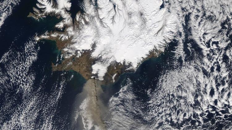
On Saturday, April 17 at 13:20 UTC (9:20 a.m. EDT), NASA’s Aqua captured a visible image of the ash plume so clearly that in the satellite image a viewer could see the billowing cloud spewing from the volcano and blowing almost due south before turning east over the Atlantic Ocean.
On Sunday, April 18 at 12:05 UTC (8:05 a.m. EDT), NASA's Terra satellite flew over the volcano and captured an image of the brown ash cloud mostly obscured by higher clouds. The brown plume was partly visible underneath the high clouds.
By Monday morning, April 19 at 12:50 UTC (8:50 a.m. EDT) the high clouds had cleared, and the brown line of spewed volcanic ash was visible once again blowing south, then turning east toward the United Kingdom."










LATEST NEWS IN travel